Since 1987, the University of Delaware has administered the Water Resource Protection Area Program for New Castle County. The purpose of the WRPA ordinance in the New Castle County Unified Development Code is to protect the quality and quantity of surface water and groundwater supplies. Under the Unified Development Code, all development within recharge, wellhead, Cockeysville formation, and reservoir water resource protection areas are required to meet maximum impervious cover thresholds (20% to 50%) and may require groundwater recharge facilities, water monitoring, and water management facilities. Presently, over 20% of New Castle County land area is protected by the WRPA provision of the Unified Development Code.
WRPA and Sourcewater Reports
- Report on Source Water Protection for the Surface Water Intakes, New Castle County, Del.
- Natural Resources in Level 1A and 1B Surface Water Source Protection Areas: New Castle County, Delaware
- Addendum to the Report on Source Water Protection for the Surface Water Intakes in New Castle County
WRPA Mapping
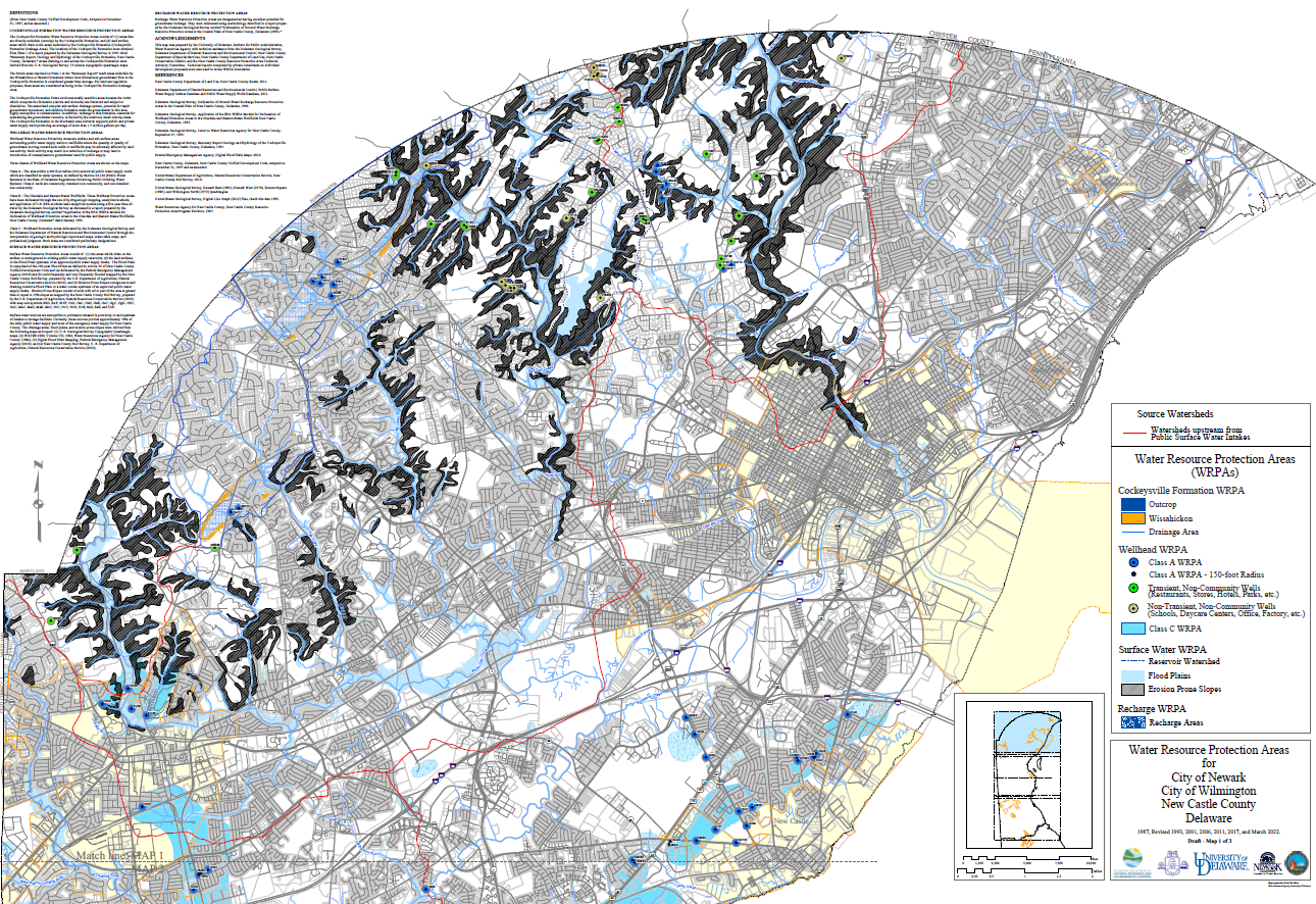
In 1987, New Castle County adopted the Water Resource Protection Area (WRPA) Ordinance, since then the maps to support this ordinance have gone through six revisions. This ordinance is contained in the New Castle County, Delaware, Unified Development Code (UDC) and protects environmentally sensitive areas that are very important to the state’s water supply and water quality. These maps depict several data layers that represent four main categories of water resource protection areas in New Castle County, Delaware. These categories are; Cockeysville Formation, Wellhead WRPA, Surface Water WRPA and Recharge WRPA. These maps serve as a decision-making tool in water resources protection areas in New Castle County, Delaware. The maps are available for downloading and printing at your convenience.
- NCC WRPA Program Revision November 1987 (pdf)
- New Castle County UDC Resource Protection Standards (pdf)
- Section 40.10.380 Water Resource Protection Area (2006) (pdf)
Final 2022 WRPA Maps for New Castle County, Delaware
- Map 1. Northern New Castle Count (2022)(4MB pdf)
- Map 2. Central New Castle Count (2022)(7MB pdf )
- Map 3. Southern New Castle County (2022)(4MB pdf)
Final 2016 WRPA Maps for New Castle County, Delaware
- Map 1. Northern New Castle County (2017) (7MB pdf)
- Map 2. Central New Castle County (2017) (3MB pdf)
- Map 3. Southern New Castle County (2017) (12MB pdf)
Final 2011 WRPA Maps for New Castle County, Delaware
- Map 1. Northern New Castle County (2011) (10MB pdf)
- Map 2. Central New Castle County (2011) (6.7MB pdf)
- Map 3. Southern New Castle County (2011) (6.5MB pdf)
The Water Resource Protection Areas are now in production on FirstMap and can be found at:
- https://enterprise.firstmap.delaware.gov/arcgis/rest/services/Hydrology/DE_NCCO_WRPA/MapServer
- https://enterprise.firstmap.delaware.gov/arcgis/rest/services/Hydrology/DE_NCCO_WRPA/FeatureServer
View the Water Resource Protection Areas for New Castle County in the mapping application below.